RoboGEO 5.2
- Categoría: Geo Tracking
- Licencia: Shareware
- Tamaño: 8.28 KB
- Sistema: w98 wNT wME w2000 wXP
- Idiomas:

A utility to geographically locate digital images.
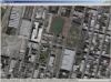
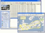
RoboGEO is a digital image reference and geographic location tool, for information included in any photo, like latitude, longitude, and altitude. This information can be added to the bottom of the photo, and you can include the EXIF metadata in the photo header. This way it lets you have the photo permanently linked to its GPS coordinates.
RoboGEO works without problems with any model of digital camera, and it already includes support for Garmin GPS systems and the importation of G7ToWin registry logs. Another interesting RoboGEO utility: an on-line map launcher to see the geographic location of photos on maps.
Remember that RoboGEO doesn´t need you to have a GPS, as the latitude and longitude can be included manually.
DownloadRoboGEO 5.2 related downloads

Garmin Mapsource 6.16.3
 Download
Update for GPS programs like Garmin or Mapsource that generates new and better maps.